


Unexpectedly to many visitors, Hong Kong is hiking heaven, with 75 per cent of its 1,106 square kilometres covered by greenery, and 40 per cent designated country parks. Mostly uninhabited mountains tower over the city, laced with accessible trails that lead you up and away from Hong Kong’s densely crowded urban areas and into an entirely different world. You’ll uncover a startling diversity of scenery, from lush forests to secluded beaches to mountain peaks while hiking in Hong Kong.
There’s a trail for every level of fitness, whether you want a gentle stroll or a more challenging climb. While you could just walk out of Central and up Victoria Peak, you’ll struggle to get away from the crowds – and with just a bit more effort, and some help from Hong Kong’s excellent public transport system, you can have a whole new side of the territory to yourself.
Credit: Getty Images
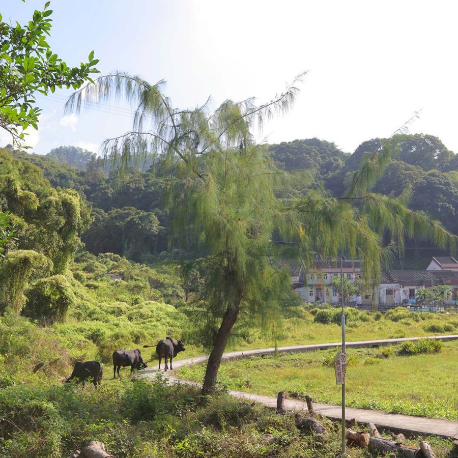
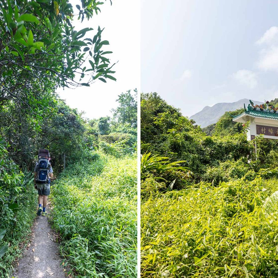
Lai Chi Wo, New Territories
Ghost Villages and Green Hills
Located in Plover Cove Country Park , in the far northeast of Hong Kong, this hike takes you through some wild and undisturbed countryside. The terrain changes through beautiful feng shui woodlands to deserted seafront and a variety of atmospheric abandoned homes formerly inhabited by Hakka people. The walk covers quite a distance but is mostly flat, with only one climb up to about 200 metres, although those also looking for dramatic views of the sea can choose to go over the 416-metre-high Tiu Tang Lung.
Distance: 16 kilometres
Time: 4-5 hours
Look Out For: The almost entirely deserted ghost village of Kuk Po
How to Get There: MTR to Fanling (an hour from Central), then the 56K bus to Luk Keng; the walk is a loop through Wu Tau Kang, Sam A, Lai Chi Wo and Kuk Po
Credit: Shutterstock
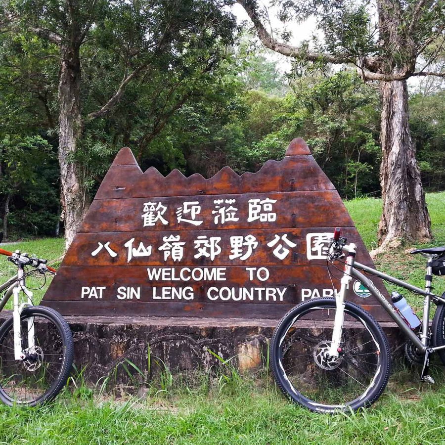
Pat Sin Leng, New Territories
Epic Views and the Eight Immortals
Only suitable for capable hikers, this is a difficult route that includes a steep climb up to 543 metres – albeit one through a pretty pine forest – but is 100-per-cent worth it for the utterly breathtaking views. The Pat Sin Leng range is a massif of eight closely interconnected 500-metre-plus peaks (its name means ‘ridge of the eight immortals’, celebrating characters from Chinese mythology) that between them afford a panorama stretching from the magnificent bay to the east to the forested Hong Kong valleys in the foreground and the imposing skyline of the city of Shenzhen looming to the north.
Distance: 12 kilometres
Time: 5 hours
Look Out For: An aerial perspective on the teeming Yantian port district across the border, to the east of the main Shenzhen skyline
How to Get There: MTR to Fanling (an hour from Central), then the 52B minibus to Hong Tau Reservoir where the trail starts
Credit: BEJRJT
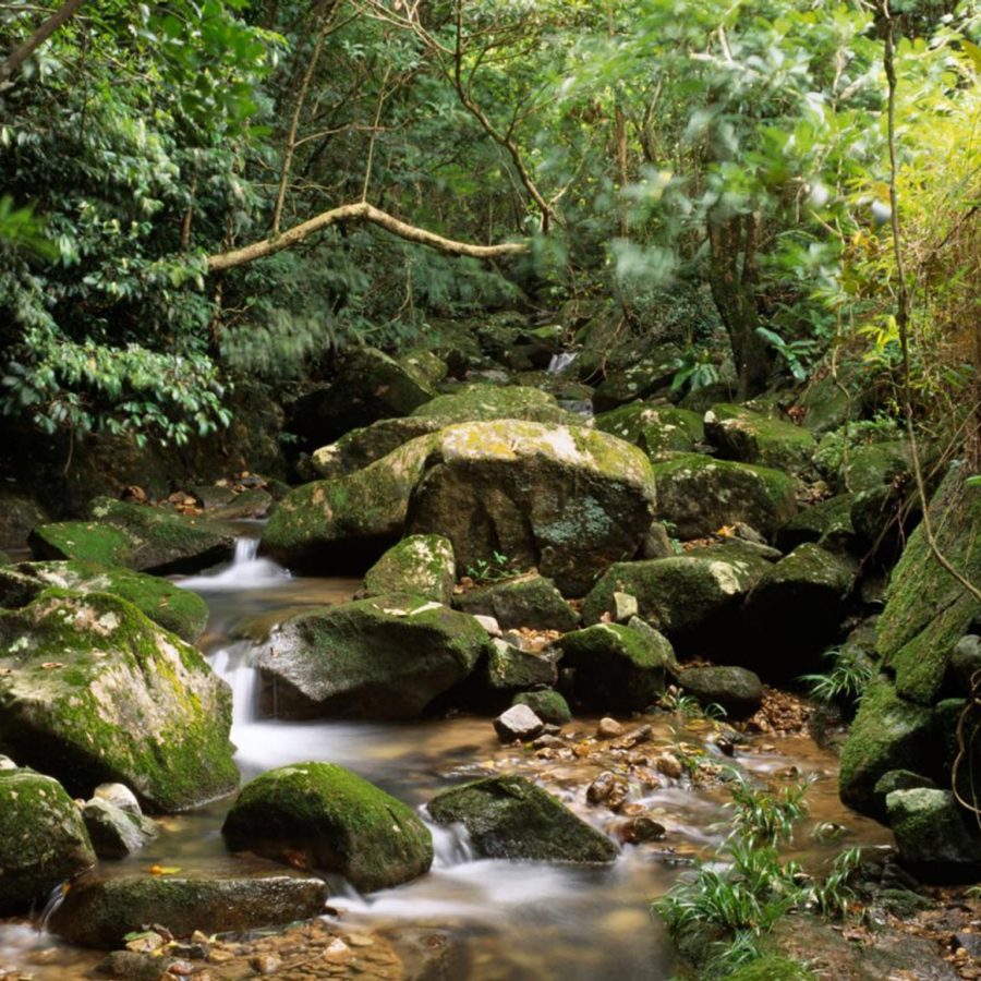
When it comes to hiking in Hong Kong, the trails often require a fair bit of uphill work. This is a unique option that involves very little climbing, but quite a lot of clambering, albeit along a beautiful stream featuring dramatic waterfalls in the New Territories’ Ma On Shan Country Park . Most of it is spent negotiating a series of giant boulders that make the stream navigable on foot, so it’s only for people who are confident in their balance and have suitable footwear, and often the only practical route is to hike through the actual stream. You probably won’t mind getting wet, however, as the payoff is a series of beautiful pools begging to be jumped into on a hot day – so pack your swimming gear.
Distance: 6 kilometres
Time: 3-4 hours
Look Out For: The gorgeous Hero’s Waterfall, complete with rock pool, which feels nothing like Hong Kong as you know it
How to Get There: MTR to Tai Shui Hang (an hour from Central), head to Tai Shui Hang North Street and follow the stairs up to a path, which soon reaches the stream
Credit; Mike Pickles
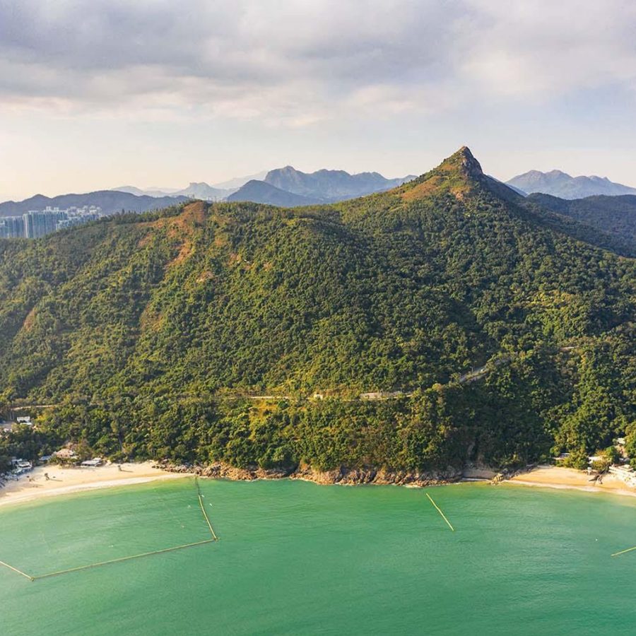
High Junk Peak, New Territories
Peak Ambitions and Epic Views
Involving one of Hong Kong’s sharpest peaks but only moderate levels of exertion, hiking Hong Kong’s High Junk Peak follows a ridge that rises to a point out of a narrow peninsula at the southeast tip of the New Territories, next to Clearwater Bay. From the summit, you’ll get views of the sea in all directions – Junk Bay to the west, with Hong Kong Island close by, islands to the north and open ocean to the south and east. There’s some steep climbing, partly through charming bamboo forests, but the peak is only 344 metres high, and you start at about 150 metres.
Distance: 6 kilometres
Time: 3 hours
Look Out For: In addition to sea views, check out the contrast between the villages to the east, the golf course to the southeast and the industrial area to the west
How to Get There: MTR to Hang Hau (40 minutes from Central), then the 103 minibus to Ng Fai Tin village, where the trail leads from the south side of Clear Water Bay Road
Credit: Mike Pickles
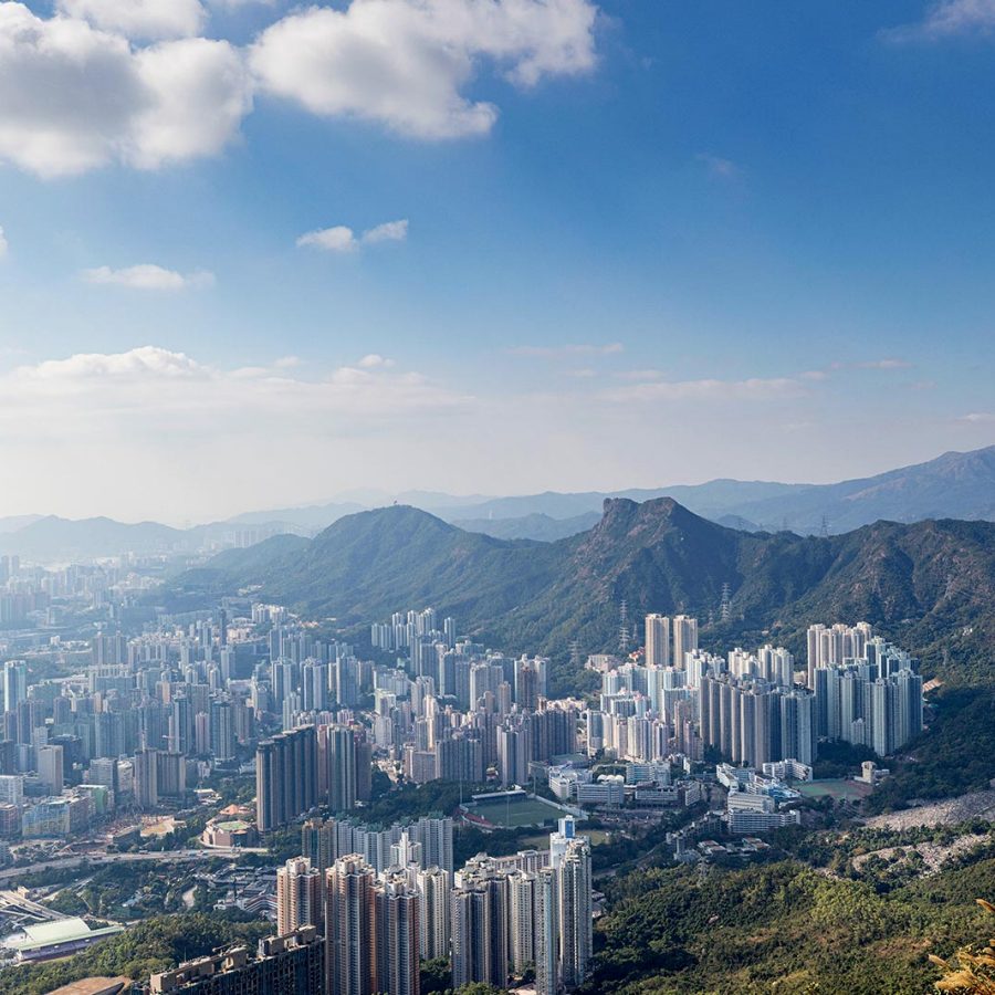
Tate’s Cairn, New Territories
Straddle Two Worlds from Up High
This hike offers the chance to feel like you’re in the mountains and in the city at the same time. Ascend to the top of Tate’s Cairn – or Kowloon Peak (Fei Ngo Shan) right next to it – and you’ll feel like you’re right on top of the clustered skyscrapers of Kowloon, with a million-dollar view over the city and the harbour beyond. Look in the opposite direction, however, and all is bucolic New Territories mountains and valleys. While it’s a pretty steep climb up to the 583-metre-high Tate’s Cairn, the terrain is solid and well maintained and the trailhead is easy to find.
Distance: 6 kilometres
Time: 3 hours
Look Out For: The final stages of the walk down along Fei Ngo Shan Road, a once glamorous area now full of crumbling mansions
How to Get There: MTR to Wong Tai Sin (40 minutes from Central), then follow Sha Tin Pass Road to the start of the trail

Credit: Mike Pickles
Sunset Peak, Lantau Island
Steep Climbs and Sumptuous Views
Come prepared for a challenge if you’re planning on hiking Hong Kong’s third tallest mountain: Sunset Peak (Tai Tung Shan) rises up to 869 metres and represents one of the territory’s most arduous climbs. You can, however, get to the summit fairly quickly, either from Tung Chung through the Wong Lung Hang valley or, if the full climb sounds a bit daunting, by starting from Pak Kung Au, a 340-metre pass on Tung Chung Road. You’ll be rewarded with some staggering panoramic views – of other mountains, the sea in every direction, most of the rest of the city, and Hong Kong International Airport right below you.
Distance: 8 kilometres
Time: 4 hours
Look Out For: The even taller Lantau Peak (Fung Wong Shan, 934 metres) rising dramatically to the west, sometimes atmospherically wreathed in cloud
How to Get There: MTR to Tung Chung (35 minutes from Central) and either walk approximately two kilometres to the start of the trail at Wong Lung Hang, or take any of the many buses along Tung Chung Road to Pak Kung Au
Credit: Mike Pickles
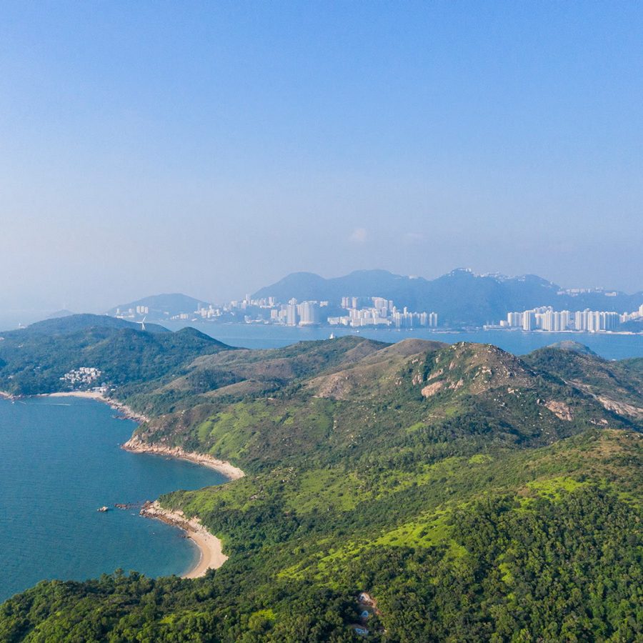
Mount Stenhouse and Ling Kok Shan, Lamma Island
Get Off-Road and Out to the Islands
A common complaint about hiking in Hong Kong is the amount of the city’s rural areas covered by concrete paths, so you never really feel like you’re walking on the wild side. Mount Stenhouse (Shan Tei Tong) is a good antidote: while it starts on a sealed path, it pretty soon gets unruly. You won’t have much company and you may sometimes be scrabbling on hands and knees, and though you may at some point feel lost just look out for the coloured scraps of material tied to trees which mark the trail. Alternatively, for those who don’t want to get their hiking gear dirty, the adjacent Ling Kok Shan has steps all the way up and down.
Distance: 7 kilometres
Time: 3-4 hours
Look Out For: The sea views are stellar throughout, but increasingly surreal after the peak, when the three towers of island’s power station swing into view
How to Get There: Ferry to Sok Kwu Wan (30 minutes from Central) and follow the path uphill towards Tung O (birthplace of film star Chow Yun-fat) as far as a crossroads near a pagoda: for Ling Kok Shan, turn left; for Mount Stenhouse, turn right
Credit: Mike Pickles
Tung Chung to Mui Wo/Discovery Bay, Lantau Island
Valley Villages and Seaside Towns
A gentler option for hiking in Hong Kong can be easily reached from the new town of Tung Chung, close to the airport. The valleys near Tung Chung are dotted with traditional villages while the gentle slopes play host to fascinating family mausoleums. Forests cover the easy route to the waterfront town and transport hub of Mui Wo; the sudden bare peak of the 465-metre-high Lo Fu Tau gets in the way of the walk to the highly developed private new town Discovery Bay, making for a startling contrast in environments. At both Mui Wo and Discovery Bay you’ll find plenty of options for a bite to eat, and ferries back to Central leave at regular intervals.
Distance: 8/12 kilometres
Time: 2/4 hours
Look Out For: Tai Ho Wan, a lake-like sea inlet that now sits next to the terminus of the Hong Kong-Zhuhai-Macao bridge
How to Get There: MTR to Tung Chung (35 minutes from Central), then follow the waterfront path east out of Tung Chung inland through the Tai Ho valley; at A Po Long, go straight on for Mui Wo or turn left for Discovery Bay
Hero image: Mike Pickles
Hong Kong travel information
- China – the Chinese Mainland, Hong Kong SAR, Macao SAR and Taiwan Region
- Hong Kong SAR - English
- Chinese Mainland (China) - English
- Taiwan, China - English
- 香港特別行政區 - 繁體中文
- 中国內地 - 简体中文
- 中國台灣 - 繁體中文
- Africa
- South Africa - English
- Asia
- Bangladesh - English
- Korea - English
- Singapore - English
- Cambodia - English
- 한국 - 한국어
- Sri Lanka - English
- India - English
- Malaysia - English
- Thailand - English
- Indonesia - English
- Maldives - English
- ประเทศไทย - ภาษาไทย
- Indonesia - Bahasa Indonesia
- Myanmar - English
- Vietnam - English
- Japan - English
- Nepal - English
- Việt Nam - tiếng Việt
- 日本 - 日本語
- Philippines - English
- Australasia
- Australia - English
- New Zealand - English